
Impact Observatory is known as a mission-driven technology company bringing AI/ML algorithms and data to sustainability and environmental risk analysis for governments, non-profit organizations, companies, and markets. To learn more about the company, Pulse 2.0 interviewed Impact Observatory Co-founder and CEO Steve Brumby.
Steve Brumby’s Background

Brumby’s career has been focused on bringing artificial intelligence (AI) algorithms and space data to global monitoring and risk analysis for the linked crises in climate, biodiversity, and sustainable development.
“I worked for over a decade to develop AI and space technology to address these issues as a research scientist at the US Los Alamos National Labs, before co-founding the venture-backed geospatial intelligence start-up Descartes Labs. I then founded and directed the National Geographic Society’s Geographic Visualization Lab with my Impact Observatory Co-Founder Samantha Hyde. Sam’s background is in climate change policy and program management at the White House,” said Brumby.
Formation Of Impact Observatory
How did the idea for Impact Observatory come together? “Working with several of the world’s leading conservation scientists and explorers at National Geographic Society proved to us the urgent need for understanding the detailed impact of human actions and the specific threats to societies from climate change, natural resource depletion, and natural disasters. Decision-makers in government, industry, and finance need better and more timely data to plan to mitigate and adapt to these threats and need detailed, timely feedback on the outcomes of their decisions. Impact Observatory’s goal is to empower global decision-makers with this timely, actionable data,” Brumby noted.
Challenges Faced
What challenges did Brumby face in building the company? “We’re a company that was started during the global pandemic, which presented lots of unusual challenges in our first year, including having to keep the doors of our first garage office open in freezing cold weather. We also benefited from building our company to be cloud-native from day one, and have learned how to attract science and engineering talent that can live anywhere in the country. Our first public good product has had a great reception, and we’ve recently bought our first commercial monitoring product to market so our main challenge right now is raising awareness of this new capability and testing it with customers,” Brumby acknowledged.
Core Products
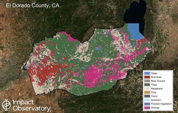
What are Impact Observatory’s core products and features? “Impact Observatory’s IO Monitor product uses AI and space imagery to map our changing world. This product is revolutionizing the way governments, industry, and finance can measure geospatial impact and anticipate change from local to a global scale, at unprecedented speed and scale,” Brumby explained. “Our maps have been independently assessed to have the best accuracy on the market. Our commercial and public-good products are released in partnership with Esri, Microsoft, AWS, and the UN, and our public-good maps have been accessed over one million times.”
Evolution Of Impact Observatory’s Technology
How has Impact Observatory’s technology evolved since launching? “We are actively working to expand the range of types of change that we can map and monitor. For example, we can now map surface water that is seasonal as well as permanent, and to distinguish land use and change within cities and townships,” Brumby noted.
Most Significant Milestones
What have been some of Impact Observatory’s most significant milestones? “Our first AI-powered map of the world was released in June 2021 and received a tremendous response from the geospatial community. That map quickly reached hundreds of thousands of accesses, and is being used by governments, industry, and even by social media companies,” Brumby highlighted. “Last year we released the first set of high resolution, annual maps of the world (2017-present), which has led to lots of interesting feedback on the amount and types of change we can see.”
Customer Success Stories
What are some of Impact Observatory’s customer success stories? Brumby told me that Impact Observatory’s maps are being used by customers including Karingani Game Reserve, Pula Properties, and the International Food Policy Research Institute (IFPRI). And the US National Geospatial-Intelligence Agency (NGA) selected Impact Observatory for a Small Business Innovation Research (SBIR) grant to develop automated land use and land cover change monitoring at higher spatial resolution.
Funding
Impact Observatory has raised $5.98 million in seed funding as of March 29, 2023. And the company is funded by investors with previous experience in AI, space, search, and mapping technology. Esri International is a significant investor in the company.
“The new investment is 100% equity and will be used to help accelerate Impact Observatory’s go-to-market strategy for its AI-powered monitoring products for governments and commercial customers. The funding will also support ongoing research and development (R&D) to build monitoring tools for the full spectrum of commercial Earth Observation systems,” Brumby added.
Total Addressable Market
What is the total addressable market (TAM) size that Impact Observatory is pursuing? “Globally, governments and industry spend over $100 billion per year to monitor geospatial assets worth trillions of dollars, from agriculture and natural resources to urban infrastructure and defense,” Brumby analyzed.
Differentiation From The Competition
What differentiates Impact Observatory from its competition? Impact Observatory’s AI-powered monitoring product seamlessly integrates space data and deep learning AI to map the changing world with the highest resolution and accuracy on the market.
The company offers:
1.) Better Resolution – The company’s fully automated land use and land cover (LULC) maps use the best available public and commercial Earth Observation data. And the company’s public good maps provide over 10 times better spatial resolution than the best national maps available today.
2.) High Accuracy – Impact Observatory has an 86% overall accuracy from their machine learning algorithms, comparable to the best maps available from national mapping agencies.
3.) Timely – Having a global map available within a week has never been available before and Impact Observatory made it possible by processing over 2 million satellite images in under a week, and can now update it in near-real-time, faster than the satellites can collect new imagery.
4.) Open Science – Impact Observatory releases its annual, global public good products under a CC-BY-4.0 license. The company uses the latest cloud-native open data standards (STAC+COG) to enable wide adoption by decision-makers.
Future Company Goals
What are some of Impact Observatory’s future company goals? “Our goal is to observe the impact of human actions and identify opportunities to protect and restore nature in harmony with sustainable development. We’re excited to be in active conversation with a number of commercial space imaging companies that are observing the Earth with an ever-increasing number and variety of satellites. Managing and extracting value from this growing flood of data is going to be a major challenge for the space community. Cloud-scale, AI-powered analysis is the key to delivering value for our customers,” Brumby concluded.